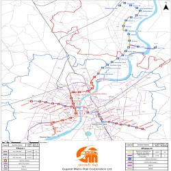
The Ahmedabad Metro map is an important tool that helps people easily understand the metro network in Ahmedabad. It shows all the metro lines, stations, and how they connect to each other. This map is very useful for commuters and tourists because it helps them find their way around the city.
The map is designed to be user-friendly, with clear lines representing each metro route. Each station is marked on the map so that people can easily see where to get on and off the metro. It also shows where you can switch between different metro lines if you need to change routes.
Sometimes, the map also includes other helpful information like landmarks, major roads, and important places in Ahmedabad. This makes it easier for people to find their destinations in relation to the metro stations. It’s really handy for exploring the city and its attractions.
The Ahmedabad Metro map is regularly updated to include any changes or new additions to the metro system. This way, people always have the most current information when planning their journeys. It’s a reliable resource for both regular commuters and people who are new to the city.
Overall, the Ahmedabad Metro map is a valuable tool that makes it easier for people to use the metro and get around Ahmedabad. It simplifies navigation and helps passengers have a smooth and enjoyable experience while traveling in the city.
(Zoom in to see stations if not visible)
